When discussing Eco Mayan Adventures we will narrow our focus to three geographical areas: (1) the Northern half of the Yucatán Peninsula (2) the area around the ancient ruins of Cobá, and (3) specifically the ancient Maya towns of U xuul ja’ (known today as Punta Laguna) and Kuki’kan.
BACKGROUND INFORMATION: THE LAND AND THE WEATHER
The Maya civilization occupied three separate areas of Mesoamerica – the Southern Highlands of Guatemala and the adjacent Mexican State of Chiapas; the Central Area of Northern Guatemala (known as the Petén) and Belize; and the Northern Region comprising primarily the Yucatecan States of Yucatán, Campeche, and Quintana Roo. For our purposes we will focus on the Northern Yucatán around the ancient city of Cobá in the eastern-most State of Quintana Roo.
The Yucatec Maya are distinct from the cultures of the rest of Mexico. To this day they differ in language, customs, dress, and even food. One reason for this is due to the geographic isolation of the Yucatán. It was not until the mid-20th century that the Yucatán peninsula was even linked to the rest of Mexico by railway and highway.
The Yucatán peninsula is a giant slab of ancient limestone jutting out into the Gulf of Mexico and the Caribbean. Its geology varies from rainforest and mountain valleys in the south near the Guatemalan border to a dry, flat land in the north. The Northern Yucatán shelf has scarcely any surface water. Instead, it is riddled with cave systems and underground rivers, access to which is sometimes possible through sinkholes (called cenotes) that were created partly by shock waves of an asteroid striking the earth off the coast roughly 65 million years ago. (There are nearly 6000 cenotes in the Yucatán.) The soil on top of the limestone is very thin, and the natural vegetation, even though it is referred to as “jungle,” is little more than scrub and a huge, brush-like forest consisting of short trees and shrubs.
The weather pattern of the whole Yucatán is essentially tropical with a long dry season extending from mid-November to early May followed by a short, rainy season extending from mid-May through early November. On the peninsula, however, the rains are less reliable than in most tropical regions, and drought is not uncommon. Being an agrarian society, the Yucatec Maya practically consider water to be a divine substance, and life to this day revolves around rain and the planting and harvesting of corn and other staple crops in accordance with the wet and dry seasons. An understanding of the land and the weather patterns is vital to understanding the development, adaptation, and history of the Maya.
BACKGROUND INFORMATION: THE ANCIENT YUCATEC MAYA
Ancient Maya cities in the Yucatán were not all the same size, nor architecturally the same style. They changed and developed over centuries, each becoming a part of a patchwork of communities which were never politically united. Instead, they resembled more the city states of Ancient Greece. Their cities varied in size and power, their relationships with each other ranging from loose alliances to direct subordination. Being primarily an agrarian society, Maya centers were in actuality sprawling agglomerations, complex systems of villages and fields supporting populations that sometimes reached into the thousands.
Having no useful metals nor native animals to be used as beasts of burden, Maya progress was due less to technical innovation and more to a complex system of mobilized collective labor. In art, architecture, trade, and astronomy the Maya were the most sophisticated of all the cultures of ancient America. They were also the only literate American culture, recording their history of names and dates with a complete writing system of hieroglyphs. After the Spanish Conquest in the 1500s, whereas most native communities were decimated or driven to extinction, the Maya and their culture survived more than any other indigenous group in Mexico and Central America.
BACKGROUND INFORMATION: MAYA SPIRITUALITY
Scholars maintain that nowhere in the ruins of the ancient period of Maya history is there any evidence of idol worship. In all of the Maya region and its historical periods, anything that could be considered idols are almost null. Although the ancient Maya worshiped the forces of nature and had a great number of divinities, e.g. animals, time, numbers, the mountain, forest, rain, and other things, they reached the idea of a unique god with absolute power, creator of all things of which these and other divinities were simply manifestations. This unique god they called “Hunab Ku,” and his son, “Itzamna,” like his father, was considered supreme and the creator of all things.
The cult of idols mentioned in records by Spanish conquistadors is not originally from the Yucatán. Instead, everything indicates that it came to the Yucatec Maya with the influence of the Toltecs from Central Mexico. For example, the cult of Kukulcán did not exist within the Maya religion before the arrival of the Toltecs who later dominated Chichen Itza.
Ancient Maya spirituality had no theological doctrine. It did, however, have logic, processes, and rituals that embraced a cosmovision used to understand, related to, and be human with all elements of nature. Science and religion for the Maya were not separate disciplines; both constituted a unity, a cosmic continuum that included all of nature, human beings, and the cosmos. This cosmovision established a need to be in intimate contact with the presence of a superior force. Moreover, in Maya thought the human being was understood to be not an individual being per se, but rather a relational being, i.e. one who could not be conceived of without having multiple relations that included one’s family, community, the earth, other persons, and all created elements.
This cosmovision lives on today in the Maya. It is reflected in principles of familial and communal relations that center on communal good, on unity, equilibrium, balance, harmony, respect, responsibility, and the consensus between parties in decisions. Even now, the Maya practice interconnectedness and participation of each member in a cooperative fashion. These principles shape and undergird contemporary Maya spirituality in a relational complementariness that holds the belief that created life is intimately related in reciprocal ties where everyone is a relative.
Contemporary Maya use the term spirituality when they speak of ways of living their beliefs. Maya spirituality is a felt and reflected-upon experience that not only perceives the interconnectedness of life, but also acknowledges and lives this belief in practical, communal ways. In its simplest form it can be expressed as “I am you; you are me” – in Mayan “in lak’ ech; a lak’ en.”
BACKGROUND INFORMATION: THE COLLAPSE OF MAYA CIVILIZATION
Archeologists have coined the term “collapse” when discussing Maya civilization because so many of their ancient cities were abandoned and left in ruins for no apparent reason. While a number of possible causes have been suggested for this “collapse”- including overpopulation, environmental degradation, warfare, shifting trade routes, and extended drought – a different perspective suggests there was not a “collapse” per se, but instead a systematic migration over centuries from the jungles of the Southern and Central regions to the Northern Region for reasons unknown. While cities like Tikal in the Petén of Guatemala were being abandoned, other cities like Chichen Itza were rising to prominence in the Yucatán. Even after the Spanish destroyed Maya ceremonial centers and enslaved survivors of the “conquest,” Maya traditions and culture did not die.
Today the Maya continue to thrive throughout Mesoamerica. They number nearly seven million souls scattered throughout the Southern, Central, and Northern regions. Nearly 500,000 Maya live in the Northern Yucatán alone. Although there are 30 distinct Maya languages (not to be confused with dialects), Yucatec Mayan predominates outside of Guatemala. (NOTE: The word Mayan is usually used when referring to the language; the word Maya is used in all other instances to describe the people and aspects of the culture.)
THE MAYA RUINS
COBA
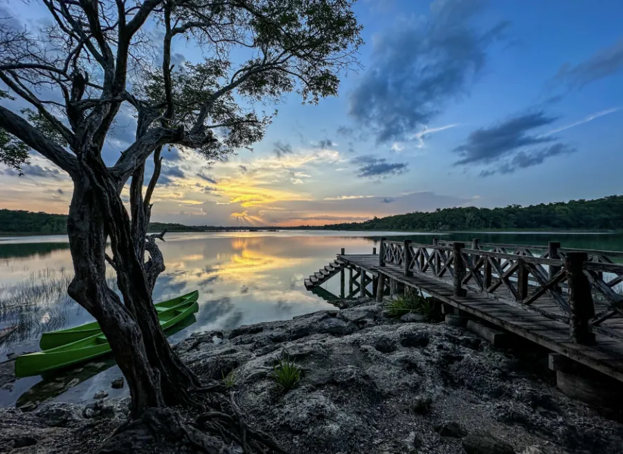
Cobá, located in the Mexican State of Quintana Roo less than two hours west of the Caribbean coast, was the second largest Maya city after Tikal which is located in the Petén region of Guatemala. It was occupied from around AD 250 and remained the largest city in the entire northern Yucatán throughout the Classic Period, reaching its zenith between AD 650 and AD 1000. Built beside five lakes, a rarity for the Yucatán, Cobá thrived under a very sophisticated system of water management. In its heyday it covered an area of some 70 square kilometers with over 15,000 structures (of which only 3% have been excavated) and had a population of nearly 50,000 inhabitants. Cobá was linked to subsidiary cities in the Yucatán by a network of well-constructed, raised stone highways called sacbés, one of the longest stretching over 100 km to Cobá’s western stronghold of Yaxuná, not far from its rival Chichen Itza. Cobá’s location gave it control of the trade routes, both by water and by land, from the Caribbean to the Gulf of Mexico. Its downfall came with the rise of Chichen Itza and a long war between the two cities. With its final defeat the Maya eventually abandoned Cobá, and it was lost in the jungle for centuries until rediscovered in 1891 by Teobert Maler. Further excavations were carried out by Eric Thompson in the 1920s and the INAH (Instituto Nacional de Antropología e Historía) in the 1970s. Our local guide, René Canul, is the son of one of the villagers who assisted archeologists in the excavation of the ruins of Cobá in 1974.
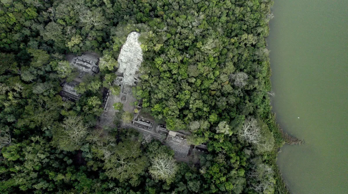
The ruins of Cobá have the tallest pyramid in the Yucatán known as Nojoch Mul.
KUKI’KAN
Kuki’kan was one of the cities linked to Cobá by a sacbé. It lies deep in the jungle, accessible only by a thirty-minute hike along a trail that offers little shade, but instead the companionship of dozens of iridescent birds and butterflies. As one hikes deeper into the undergrowth, their peaceful presence gives way to more ominous jungle critters like marching army ants, poisonous spiders, and colonies of cutter ants. (Thankfully no snakes or mosquitoes at this time of the year.) It does not take much imagination to transport oneself back to the explorations of Eric Thompson in the early 1900s when he explored Cobá and Kuki’kan, writing of his impressions in his book, Maya Archeologist.
A “suburb” of Cobá, Kuki’kan is surrounded by a wall (now in ruins) and within that wall lie numerous unexcavated ruins suggesting the presence of “high-rise” apartment buildings fronting a central plaza probably used as a market place or for other commercial activity. The walls of the buildings are smooth with a stucco called saaskab made from bee honey
mixed with pulverized limestone. On walls that have been protected from the weather by roofs or the famous Maya arch one can still see the original red paint that colored most Maya buildings (contrary to our conception of the buildings looking more like the colorless ruins). The paint was actually made from the bark of a tree. One can even see some of the original wooden door lintels made from the jaabin tree, a hardwood that does not deteriorate over time.
U XUUL JA’ (TODAY KNOWN AS PUNTA LAGUNA)
U xuul ja’ is another ancient site located approximately 20 km from the ruins of Cobá. Although its origins may go back to 300 BC, it thrived at the same time as Cobá and was probably connected to the city by one of the many sacbés. The site includes a series of caves, over 150 structures, several stelae (carved pillars resembling totem poles), and a cenote that was used as an ancient Maya cemetery. Some of the structures still seen are actually platforms that would have supported houses, administrative buildings, and places of worship.
Fifty years ago three brothers from the Canul family working as chicleros (men who extracted the chicle latex resin from the zapote tree to make chewing gum) came upon a huge stand of zapote trees in the middle of the jungle with Maya ruins and a beautiful lagoon. It was the site of ancient U xuul ja’. They renamed it Punta Laguna, meaning “Lagoon Point.”
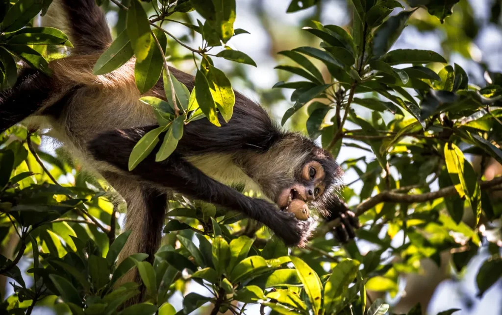
Some years later the sons of the Canul brothers began to take an interest in protecting the ruins of U xuul ja’ and the surrounding jungle. As time went by others gained an interest in their efforts, especially to protect the animals that inhabited the forest, among them the puma, howler monkeys, and spider monkeys. For over 40 years scientists from around the world have been using Punta Laguna as a primate observation center, especially of the spider monkeys.
In 2002, after 30 years of local efforts to conserve the area, over 5000 hectares were declared a sanctuary by the Mexican government. In Yucatec Mayan the reserve is known today as “Otoch Ma’ax Yetel Kooh” – the Home of the Spider Monkey and the Puma. Today Eulogio Canul, the father of Jesús Canul, our guide and the founder of Eco Mayan Adventures, is an Assistant Biologist working in collaboration with international investigators to collect data about the habits of the nearly 600 spider and howler monkeys that call Otoch Ma’ax Yetel Kooh their home.
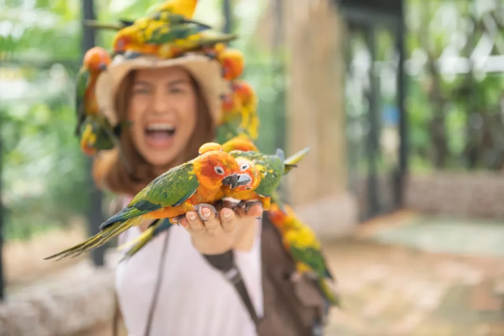
Yucatán spider monkeys are one of the largest species of New World monkeys. They are found in the Yucatán peninsula, Belize, and northern Guatemala. They are very social and live in female-dominated groups of 10 to 100 members. Feeding mostly on fruits, their average life span is 25 years. The larger black howler monkeys, known in the Yucatán as the saguaro, live in groups of 6 to 12, eat top canopy leaves, and come out only during the day. They are famous for their loud howls which sound like dinosaur cries from Jurassic Park.
Of particular interest is that both the spider monkeys and the howler monkeys have a prehensile tail which can support their body weight. This tail is actually an evolved “grasping” appendage found only in monkeys in the New World (i.e. Central and South America). Old World monkeys in Africa and Asia do not have prehensile “grasping” tails; their tails are simply regular tails. Scientists believe that the difference in tails is related to differences in the types of forests. Central and South American forests have many hanging vines which the monkeys use to traverse between trees. In contrast, the forests of Africa and Asia have far fewer vines so monkeys usually go to the ground to travel between trees.
CHICHEN ITZA
Chichen Itza is among the most extensively excavated sites of the great Maya cities. It is a UNESCO World Heritage Site and has been called one of new Seven Wonders of the World.
Chichen Itza rose to prominence around 600 AD. Differences in architectural styles of buildings suggest that it may have been a hybrid, cosmopolitan community inhabited at various times by a mix of both Maya and non-Maya peoples from different parts of Mesoamerica. Its history, as such, is rich, but complex. Noteworthy, is the influence of the Toltecs of Central Mexico who migrated to the Yucatán around AD 1000 and built the largest part of the city. Chichen Itza’s glory days were relatively short lived, lasting only to about AD 950, but during that time its conquest of Yaxuná and Cobá around AD 860 left it with few rivals. It began its decline as a regional center by 1100 AD., its prominence eventually being replaced by Mayapan, the last of the great Maya centers to rise in the Yucatán before the Spanish Conquest.
Chichen Itza was a Maya ceremonial center where the gobernantes (those who governed the people) performed sacred rites and instructed the populace in ways to maintain spiritual balance in their lives. In a sense these centers were not unlike our religious centers (i.e., churches, synagogues, or mosques) where leaders (i.e., priests, pastors, rabbis, or imams) instruct congregants in the ways of their religion. It should be pointed out that the Spanish-derived names given to the buildings by archeologists, such as El Castillo, the Nunnery, the Caracol, and Iglesia, have nothing to do with their
original functions. Maya spirituality, with a focus on balance and equilibrium, was the foundation of Maya culture, and the buildings of Chichen Itza served the purpose of aiding the Maya in their search of the stars and the cosmos for ways to bring harmony and balance into every aspect of their lives, from daily routine to architecture to religious ceremonies.
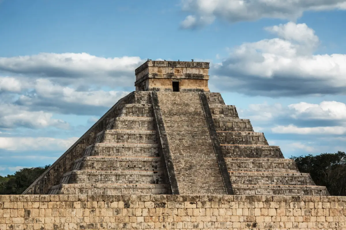
One idol who played a significant role was Kukulcán, the god of the planet Venus who also represented the god of the wind. Of particular interest is that this feathered snake god did not originate with the Yucatec Maya. It was brought to the Yucatán from the Central Highlands by the Itzaen Putuns and the Toltecs. With the cult to Kukulcán the Toltecs brought idolatry, human sacrifices, self-immolations, and the grand religious ceremonies which were carried out with great splendor and majesty. Several buildings in Chichen Itza are associated with the cult to Kukulcán, especially the largest pyramid, El Castillo. Every year during the spring and fall equinoxes when the sun hits the exact right point the shadow cast on El Castillo makes it look like a serpent is slithering down the steps!
MUYIL/SIAN KA’AN BIOSPHERE
In Mayan the Muyil ruins are known as Chunyaxché. Closely associated with Cobá, with its decline came the decline of Chunyaxché. These ruins resemble Petén architecture and are similar to those of Tikal in northern Guatemala. In one of the temples it’s still possible to see some of the original painted stucco in yellow, red, black, and Mayan blue.
Close to Muyil is the Sian Ka’an Biosphere, another UNESCO site, which in Mayan means, “where heaven is born.” It is a huge area of uninhabited lagoons, reefs, mangroves, tropical forest, and savanna which is home to jaguars, crocodiles, turtles, manatees, and thousands of birds. It follows the canoe trading routes of the ancient Maya to the Caribbean and is the most comprehensively protected natural area environment in all of Mexico.
OTHER POINTS OF INTEREST RELATED TO THE MAYA
NEYMA THE CURADORA
Neyma, the Maya herbalist, is similar to our functional medicine doctors. She uses jungle herbs and plants to concoct ointments and oils to heal. She also practices massage to keep the body aligned and in balance, both internally and externally. Neyma’s practice is consistent with the Maya spiritual focus on balance and harmony.
MAYA HOMES
Maya homes traditionally consist of three basic components: a structure for sleeping, a separate structure for cooking, and a backyard called a solar, or in Mayan a táankab. Some of the Maya continue to live in traditional palapas made of sticks and thatched roofs, but most of the homes are a combination of palapas and brick structures with brick and/or thatched roofs. In its own way each homestead is a well-ordered and extremely functional environment that meets the daily needs of the Maya and sustains their ancient way of life. Although the buildings may look unfinished to our Western eyes, it must be remembered that building projects are usually completed over a long period of time to accommodate cash flow issues and/or a lack of available materials.
While most backyards in America are designed for recreation, the solar is not only the place where children play, but also where clothes are washed, tools are fabricated or repaired, animals are raised, and the corn is cooked, washed, and prepared for meals. In essence, each Maya solar is virtually a mini-farm that provides the family with most of its basic food needs. A solar will usually have a variety of trees (e.g., mango, papaya, lemon, avocado, and achiote), a variety of edible bushes and plants (e.g., chaya, nopal, squash, corn, yuca, and beans) as well as pens for pigs and turkeys. Chickens and ducks usually roam free-range. The solar is also where the family washes clothes, may have their outdoor gravity-fed “flush” toilet, and does underground cooking in pibs. All of this is usually on an acre or less of property.
Electricity and “city” water are relatively recent additions to many villages. Electricity did not arrive in Puntal Laguna until the early 2000’s. Around the same time underground cenotes were tapped to create a water tower from which water would flow into the homes. Prior to that all villagers needed to haul water daily from the local well or cenote.
NOJOCH KEEJ
Nojoch Keej is an endangered animal rescue conservation and education project run by Don Manuel Trinidad. He has been doing this for nearly 47 years, first with his grandfather and father and now with his sons Jesús, Sebastian, and Eduardo. His wife María and daughter Lupita cook the family/guest food and care for three cabañas that serve as lodging for guests and volunteers. The grounds are orderly and artistically designed, resembling a botanical garden.
Don Manuel receives the majority of the animals from government officials who bring them to him to rehabilitate from people who have kept them illegally. Some he returns to the jungle, but most need to be kept at his place because they would no longer survive in the wild. His animals include deer, ocellated turkeys, sting-less Melipona bees (which are famous for their rare honey), and other animals known only to the Yucatán. In order to maintain the balance of nature (again, a Maya mindset rooted in their spirituality) Don Manuel mates those animals who cannot be returned to the wild with the intention of returning their offspring to the jungle. Restoration, however, is not limited to animals. Don Manuel also has an extensive nursery in which he raises orchids and a variety of trees to reforest the jungle. Most of Don Manuel’s work is financed through donations from guests and volunteers who want to support his efforts and vision.
THE MILPA
The method of agriculture employed by most Yucatecan farmers today is the same as that used by their ancestors. It is called slash-and-burn and is carried out on a plot of land known as the milpa. The full cycle of farming begins during the dry season from November through January when old-growth trees of the forest are cut down, today mostly by hand with machetes (in contrast to stone axes and adzes of pre-Columbian times). After the cut vegetation is collected for firewood and charcoal, the remaining trees and brush are left to dry. Then between March and May the land is systematically burned and cleared.
NOTE: This land is NOT level with rich topsoil as are most farms in the United States. The ground is extremely rocky and uneven, the topsoil shallow and dispersed among the rocks. Looking at the land one immediately asks, “what can possibly be grown here?” By the end of May or the beginning of June the rainy season begins. Traditional rain ceremonies called ch’a’cháak often precede the planting. At this time each farmer methodically plants his milpa by hand, probing the ground with a pointed planting stick to find any spot deep enough to hold a mixture of corn, squash, and bean seeds that will germinate if there is enough rain during the growing season.
The milpa plays such a significant role in the lives of the Maya that entire villages have moved and started anew to find new land to cultivate. Some scholars have even suggested that the rise and decline of pre-Columbian Maya cities over time may have also been related to this type of agrarian migration. So important is the milpa to the Maya that they even lost their chance for independence from Spanish landlords over it.
During the mid-1800s revolt known as the Caste War, Maya victory was nearly at hand. Then the Maya suddenly went away. In one of the most extraordinary episodes in the war, winged ants appeared indicating the early arrival of rain. To the Maya this meant that it was time to begin their year’s planting, without which they could not eat. So, thinking they would resume fighting after the crops were planted, they simply went home, leaving the militia fighting against them to regain strength and ultimately victory.
HACIENDA MUCUYCHE & CENOTES
No history of the Yucatecan Maya would be complete without at least touching upon the hacienda system that virtually enslaved them. Hacienda Mucuyché, which dates back to the 17th century, belonged to the Peon family for the growing of henequen, an agave-like plant used in the making of rope. (Because henequen was originally shipped from the Yucatecan port of Sisal, it erroneously became known as “sisal” around the world.) Today the ruins of this hacienda are just one of the many painful reminders of the way the Maya were treated under the Spanish. The cenote at Mucuyché is famous because in 1865 the Mexican Empress Carlota was one of first persons to actually swim in a cenote, since cenotes had been considered sacred by the Maya who used them simply for water supplies and religious offerings.