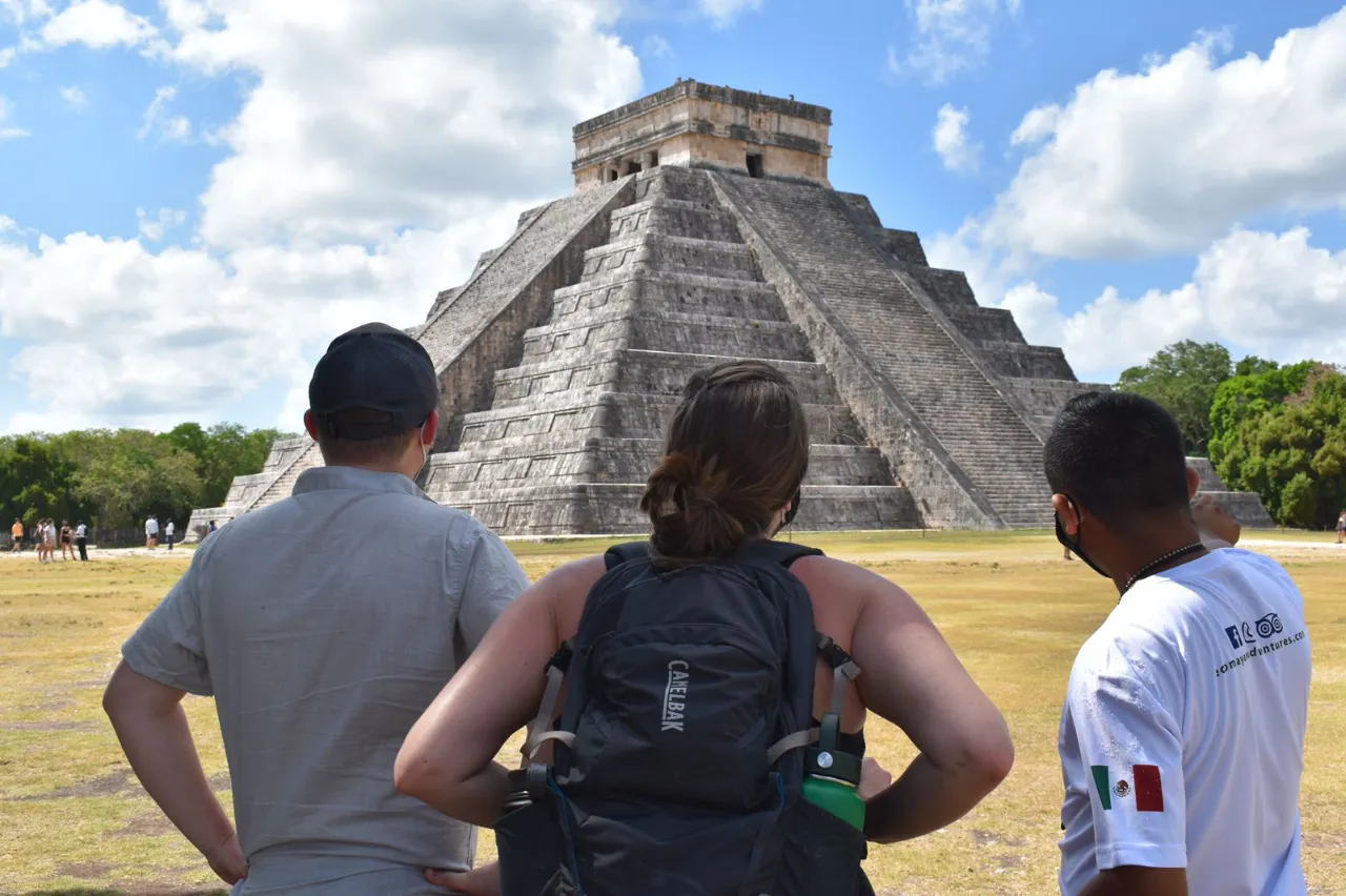
Chichen Itza is located in the heart of the Yucatán Peninsula, specifically in the municipality of Tinúm, Mexico. Its geographic position plays a crucial role in its accessibility and cultural significance for visitors exploring the rich heritage of the Maya civilization. The site is approximately 120 miles from Cancun and 31 kilometers from Valladolid. This strategic location makes it a key destination for tourists traveling across the region, offering a unique opportunity to experience ancient history and natural beauty in one visit.
Understanding the Geographic Location of Chichen Itza
The geographic placement of Chichen Itza is a pivotal aspect of its historical and cultural significance. Understanding its location helps to appreciate the connections it fostered throughout the Maya civilization.
Position Within the Yucatan Peninsula
Chichen Itza is strategically located in the heart of the Yucatan Peninsula, which served as a vital area for trade and cultural exchanges among various Mayan city-states. This ancient city’s position allowed it to play a leading role in politics, economy, and religion during its peak.
Coordinates and Map Overview
The precise coordinates of Chichen Itza are 20.6843° N latitude and 88.5678° W longitude. This geographic pinpointing places it within a lush, tropical setting, surrounded by the unique eco-systems of the Yucatan. When viewed on a map, the site reveals its centrality, which is enhanced by nearby water bodies and extensive road networks.
Proximity to Key Cities in Mexico and Central America
The location of Chichen Itza offers convenient access to several significant urban areas, making it an easily accessible site for both tourists and scholars interested in its vast history and cultural legacy.
Distance from Cancun and Accessibility
Situated approximately 120 miles (193 kilometers) from Cancun, the most common way for visitors to reach Chichen Itza is through organized tours or private transportation. The journey takes around 2.5 hours, providing breathtaking views of the Yucatan landscape.
Connection with Valladolid, the Nearest City
Valladolid, located merely 31 kilometers away, serves as the nearest city to Chichen Itza, allowing visitors a quick trip of about 30-40 minutes by car. This proximity has made Valladolid a popular base for exploring the archaeological site.
Routes from Playa del Carmen and Tulum
For travelers originating from Playa del Carmen, the distance to Chichen Itza is roughly 180 kilometers, which translates to a drive of approximately 2.5 hours. Tulum is slightly further away, with an estimated travel time of 2 hours, accessible via Highway 109, ensuring that visitors can enjoy scenic routes along the way.
Accessibility from Merida and Izamal
Merida, the capital of Yucatan, lies about 120 kilometers west of Chichen Itza, making the site just a 1.5-hour drive from the city. Izamal, known for its stunning yellow buildings, is also in close proximity, being a mere hour away. These connections pave the way for enriching experiences combining cultural exploration with visits to Chichen Itza.
The Significance of Chichen Itza’s Location in Maya History
Understanding the historical significance of Chichen Itza’s location provides insight into its impact on the Maya civilization. The site’s positioning served multiple strategic purposes during its peak.
Role in the Classic and Postclassic Periods
Chichen Itza emerged as a prominent center during both the Classic and Postclassic periods of Mesoamerican history. Initially, during the Classic period, it was influenced by established city-states, which contributed to its growth and development. The shift to the Postclassic era, around 900 AD, saw it rise to prominence as a major political and cultural hub. Its geographical placement allowed for strategic alliances and control over trade routes, effectively shaping its role in the Maya world.
Political and Economic Importance in the Northern Yucatan
From a political standpoint, Chichen Itza was crucial in the northern Yucatan region. Its location enabled the consolidation of power, attracting various groups and leaders. The city functioned as a locus of governance and decision-making, influencing the surrounding areas. Economically, it thrived due to its access to trade routes that spanned across the Yucatan Peninsula. Goods exchanged included textiles, precious stones, and food products, establishing it as an essential player in regional commerce.
Influence of Location on Trade and Cultural Exchange
The strategic location of Chichen Itza facilitated trade and cultural exchanges with neighboring regions. Due to its proximity to important waterways and routes, it became a melting pot of diverse cultures. The site’s connectivity played a vital role in cultural diffusion, as migrants from various parts of Mesoamerica brought different customs, practices, and architectural styles. This cultural exchange enriched the Maya civilization, making Chichen Itza a significant contributor to the broader cultural landscape.
Relationship with Other Ancient Maya Cities
Chichen Itza’s location allowed it to establish relationships with other notable ancient Maya cities. Due to its positioning, it acted as a bridge between diverse cultural and political entities. Interaction with cities like Tikal, Copán, and Uxmal, facilitated through trade and diplomatic channels, significantly influenced its development. These relationships were often marked by alliances, competition, and shared cultural practices, highlighting the interconnected nature of Maya civilization.
Mapping Chichen Itza: Exploring the Site’s Layout and Surroundings
Understanding the layout and key structures of Chichen Itza provides insights into its historical significance and architectural marvels. This ancient site is an intricate blend of religious, political, and cultural elements, reflected in its carefully planned surroundings.
Overview of Major Structures and Their Placement
Chichen Itza is home to several iconic structures that showcase the impressive architectural skills of the Maya civilization. These buildings are strategically placed to serve various ceremonial and functional purposes.
The Pyramid of Kukulkan (El Castillo)
This monumental pyramid stands as the centerpiece of Chichen Itza. Known as El Castillo, it symbolizes the link between heaven and earth for the Maya. With its precise alignment, the pyramid is renowned for the shadow effect seen during the spring and autumn equinoxes, when the sunlight casts a serpent-like shadow down its staircase.
The Great Ball Court and Its Location
A key feature of the site, the Great Ball Court, is the largest of its kind in Mesoamerica. Positioned adjacent to the main pyramid, its layout reflects the importance of the ball game in Maya culture. The acoustics of the court are remarkable; a whisper at one end can be heard clearly at the other, emphasizing the significance of communication in these ceremonial activities.
The Temple of the Warriors and Thousand Columns
The Temple of the Warriors showcases a combination of architectural styles indicative of Maya society’s complexity. This temple, surrounded by hundreds of columns, features ornate carvings and significant sculptures, statement pieces of craftsmanship that speak to the artistic talents of the era.
The Cenote Sagrado and Its Geographic Position
The Sacred Cenote, a natural sinkhole, played a critical role in Maya rituals. Situated just outside the main architectural area, it served as a site for offerings and sacrificial ceremonies, attracting immense spiritual significance throughout Chichen Itza’s history.
Interpretation of Chichen Itza’s Central Platform Arrangement
The central platform of Chichen Itza reflects an organized layout designed to facilitate social and religious gatherings. The placement of structures like the Pyramid of Kukulkan and the Great Ball Court forms a triangular arrangement that points to significant celestial events. This arrangement not only illustrates the advanced astronomical knowledge of the Maya but also emphasizes the communal aspect of their society through physical proximity.
GIS and Modern Mapping Techniques Applied to the Site
Advances in technology have enhanced the understanding and preservation of Chichen Itza’s layout. Geographic Information Systems (GIS) are now utilized to create detailed maps that uncover hidden structures and analyze spatial relationships. These modern mapping techniques enable researchers to visualize the site’s development over time. By employing LIDAR (Light Detection and Ranging), archaeologists have identified previously unrecorded features, further enriching knowledge about this ancient civilization’s cultural landscape.
Accessibility and Travel Logistics to Chichen Itza in 2026
As tourism continues to flourish in Yucatán, the accessibility of Chichen Itza stands as a vital aspect for travelers seeking to explore this magnificent archaeological site.
Transportation Options from Major Tourist Hubs
Getting to Chichen Itza is easier than ever, thanks to the variety of transportation options available from several major tourist hubs in the region.
Organized Tours Versus Self-Drive
Many visitors opt for organized tours, which offer a hassle-free way to experience the site. These tours typically include transportation, a knowledgeable guide, and sometimes additional stops at nearby attractions. This option allows guests to fully immerse themselves in the journey without the stress of navigation or parking.
On the other hand, self-driving provides the flexibility to explore at one’s own pace. Major rental car companies are available in cities like Cancun and Playa del Carmen, offering an easy way to reach Chichen Itza. While the drive can take around two to three hours, travelers can enjoy a scenic route featuring local landscapes and roadside attractions.
Public Transit Availability and Routes
Public transportation is another viable option for reaching Chichen Itza. Buses operate regularly from cities like Cancun, Valladolid, and Merida, providing affordable access to the site. The bus terminals in these cities offer reliable schedules and comfortable rides, making it easier for budget-conscious travelers to plan their visit.
Infrastructure Supporting Visitor Access
The continuous improvement of infrastructure enhances the experience for visitors to Chichen Itza. This development is vital for managing the increasing number of tourists drawn to this UNESCO World Heritage site.
Road Networks and Highways
Major highways connecting Chichen Itza with other cities have undergone significant upgrades. The roads are well-maintained, ensuring smooth travel. The most common routes include the Carretera 180 from Cancun and the Ruta 295 from Valladolid. These connections facilitate efficient access to the site, showcasing a growing interest in promoting cultural tourism.
Parking and Visitor Facilities Near the Site
Ample parking is available for visitors arriving by car. The designated parking areas are conveniently located near the entrance to Chichen Itza, allowing for easy access to the facilities. Upon arrival, guests will find amenities such as restrooms, souvenir shops, and food vendors catering to the needs of tourists.
Sustainable Travel Considerations for Eco Mayan Adventures
Sustainability is a key focus for eco-friendly travel in Yucatán. Efforts are being made to minimize the environmental impact associated with tourism. Travelers are encouraged to consider eco-friendly transportation options.
Carpooling and using shuttle services can help reduce the carbon footprint. Additionally, engaging with local tour operators who prioritize sustainable practices ensures that visitors can enjoy the beauty of Chichen Itza while supporting the local economy and preserving the environment.
The Location of Chichen Itza Within the Context of World Heritage and Tourism
The location of Chichen Itza is central to its status as a UNESCO World Heritage site and a major tourist attraction. This section explores the significance of its geographic positioning in relation to global heritage and its impact on tourism.
UNESCO World Heritage Status and Its Geographic Implications
Designated as a UNESCO World Heritage site in 1988, Chichen Itza’s location plays a pivotal role in its preservation and recognition. The geographic setting within the Yucatán Peninsula highlights both the cultural and historical significance of the site. UNESCO’s acknowledgment underscores the importance of safeguarding this heritage, considering its unique contributions to the understanding of Maya civilization.
Furthermore, its accessibility enhances its status as a global tourist destination, allowing millions to experience its historical richness while promoting cultural preservation initiatives. This designation not only attracts visitors but also emphasizes the need for sustainable tourism practices to protect the site’s integrity.
Impact of Location on Tourist Numbers and Seasonality
Chichen Itza’s strategic placement near major cities leads to fluctuating visitor patterns throughout the year. Accessible from hotspots like Cancun and Valladolid, the site experiences a surge of tourists during peak season, which typically aligns with the winter holidays and spring breaks. This increase can strain local resources, affecting visitor experience and conservation efforts.
Conversely, the off-peak seasons provide quieter opportunities for exploration. Understanding these seasonal trends is crucial for managing tourism flows and implementing measures to mitigate environmental impacts. Local tour operators increasingly tailor offerings to promote visiting during less crowded times, fostering a more enriching experience.
Strategic Position Among New Seven Wonders of the World
Chichen Itza’s recognition as one of the New Seven Wonders of the World amplifies its appeal to travelers worldwide. This distinction highlights its exceptional architectural achievements and the advanced understanding of astronomy demonstrated by the Maya civilization. The allure of visiting a site recognized globally fuels tourism growth, enhancing its international visibility.
Being in this elite group influences travel itineraries, as many tourists prioritize visiting these wonders during their trips. The location’s integration into broader travel packages not only boosts local economies but also elevates the cultural dialogue surrounding ancient civilizations.
Location-Based Ecotourism Opportunities and Conservation Efforts
Chichen Itza’s rich ecological context offers unique opportunities for ecotourism. The surrounding natural beauty, including cenotes and lush jungles, can enhance the visitor experience while promoting conservation efforts. Tour operators increasingly emphasize eco-friendly practices by offering guided tours that educate visitors about the importance of environmental conservation and the need to protect both the archaeological site and its natural landscape.
Partnerships with local communities can further bolster these initiatives, creating a sustainable approach that respects both cultural heritage and biodiversity. Efforts to involve local populations in preservation activities not only strengthen community ties but also enrich the visitor’s understanding of the land they traverse.
Chichen Itza’s Location and Its Relationship with Surrounding Natural Features
The location of Chichen Itza is intimately connected with its surrounding natural features, significantly influencing its historical development and cultural significance. The unique geological characteristics of the region play a vital role in both the ecosystem and the architectural design of the site.
The Yucatan’s Karst Topography and Cenotes
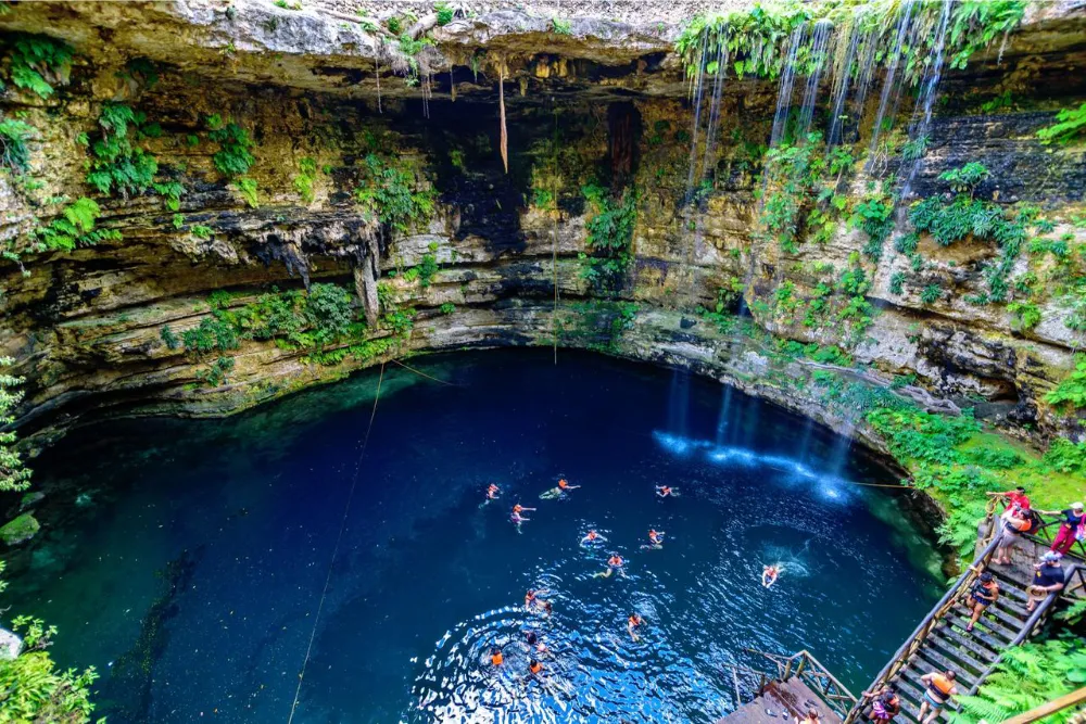
The Yucatan Peninsula, where Chichen Itza is located, is renowned for its karst topography. This geological formation has produced an extensive network of underwater rivers, caves, and numerous cenotes. Cenotes are natural sinkholes created by the collapse of limestone bedrock, revealing the water underneath. These formations are central to the region’s ecosystem and have been crucial to the Mayan civilization.
- Cenotes served as primary water sources for the inhabitants, especially during dry seasons when surface water was scarce.
- They also held spiritual significance, often used for rituals and offerings to deities, reflecting the deep connection between the Maya and their environment.
The Role of the Sacred Cenote in Site Planning
The Sacred Cenote, located near Chichen Itza, was integral to the site’s layout and cultural practices. This cenote is one of the most famous in the Yucatan, often associated with significant religious ceremonies.
- It is estimated that numerous artifacts, including ceremonial offerings, have been discovered in its waters, further emphasizing its importance in the Mayan belief system.
- The placement of major structures in relation to the cenote reveals a deliberate and thoughtful approach to urban planning among the Maya.
Environmental Setting and Its Influence on Site Development
The environmental aspects surrounding Chichen Itza have played a significant role in shaping its development. The lush jungles surrounding the site provided materials for construction and influenced the agricultural practices of the inhabitants.
- The dense vegetation enabled the sustainable use of resources, supporting a diverse array of plant and animal life, which the Maya depended on for food and materials.
- This rich biodiversity also contributed to the region’s ecological balance, enhancing the area’s natural beauty and offering a habitat for various species.
Biodiversity and Protected Areas Around Chichen Itza
In recent years, there has been a push to establish protected areas around Chichen Itza to preserve its natural environment. Efforts to maintain the biodiversity of the region are crucial for ecological sustainability and cultural heritage.
- Protected areas help safeguard many plant species unique to the Yucatan, which are critical to local ecosystems and agricultural practices.
- Moreover, these initiatives aim to strike a balance between tourism and environmental conservation, ensuring that the natural resources surrounding the archaeological site are preserved for future generations.
Historical Mapping and Early Explorations of Chichen Itza
The rich history of Chichen Itza has been unearthed through decades of exploration and mapping, revealing the site’s intricate design and cultural significance. The contributions of early explorers laid the groundwork for understanding this ancient marvel.
Edward Herbert Thompson’s Contributions and Mapping
Edward Herbert Thompson, an American archaeologist, played a crucial role in the early exploration of Chichen Itza beginning in the late 19th century. His explorations helped bring international attention to the site. An advocate for the preservation of Maya culture, Thompson conducted extensive surveys and excavations that uncovered numerous structures and artifacts.
Among his notable achievements was the mapping of key areas within Chichen Itza. He documented the grand Pyramid of Kukulkan, which became a focal point for understanding Maya architectural techniques. His exploration of the Sacred Cenote revealed several offerings that provided insights into the spiritual practices of the Maya civilization. His commitment to both archaeological rigor and the promotion of Maya heritage remains influential.
Evolution of Archaeological Surveys and Location Records
Over the years, the methodologies used in archaeological surveys at Chichen Itza have evolved significantly. Initial maps created by explorers like Thompson were rudimentary compared to contemporary techniques. Early surveys often relied on visual observations and written records, which limited the accuracy of the findings.
With advances in technology, modern surveys utilize various mapping techniques, such as aerial photography and satellite imagery. These methods have allowed archaeologists to create detailed topographical maps, facilitating the identification of previously unrecorded structures. The integration of Geographic Information Systems (GIS) has further enhanced the accuracy of location records, paving the way for research that connects Chichen Itza with other significant archaeological sites.
Spanish Accounts and Changes in Site Awareness
The Spanish colonization in the 16th century marked a turning point in the awareness and documentation of Chichen Itza. Initial encounters brought about varied perspectives, as some explorers were astonished by the grandeur of the ruins while others viewed the site through a lens of conquest and spiritual conversion.
Most notably, accounts from Spanish missionaries and chroniclers provide fascinating narratives regarding the social dynamics and religious practices of the Maya. These reports, while influenced by the biases of their authors, highlighted the significance of Chichen Itza in the context of Maya civilization and contributed to its historical legacy. Over time, these narratives evolved, shaping the perception of Chichen Itza and enticing further exploration.
Modern Archaeological Mapping Techniques and Discoveries
In the contemporary era, mapping techniques have significantly improved, allowing archaeologists to uncover buried features and better interpret the site’s layout. Advanced technologies such as ground-penetrating radar and LiDAR (Light Detection and Ranging) have revealed hidden structures beneath the dense jungle canopy.
- Ground-penetrating radar has been instrumental in identifying subsurface features without the need for extensive excavation.
- LiDAR enables researchers to generate precise 3D models of the terrain, revealing the extensive urban planning of the ancient Maya.
- These techniques have led to discoveries of previously unknown plazas, temples, and water management systems that reflect the site’s complex history.
These innovations contribute to a deeper understanding of how Chichen Itza functioned as a politically and economically significant center during the height of the Maya civilization. The ongoing integration of technology in archaeological practices continues to shed light on this ancient city, ensuring its history is better preserved and appreciated.
Planning Your Visit: Using Location Information for an Authentic Experience
Understanding the best ways to approach Chichen Itza can greatly enhance the visitor experience. With its rich history and geographical significance, careful planning is key to making the most of the trip.
Recommended Itineraries Starting from Different Cities
Cancun-Based Routes and Guided Tours
Traveling from Cancun to Chichen Itza is a popular choice. Numerous tour operators provide comprehensive packages that include transportation, guided tours, and even meals. These tours often feature early morning departures to avoid crowds, allowing for a more immersive experience. Visitors can opt for half-day or full-day tours, which frequently combine stops at other intriguing sites such as cenotes or nearby archaeological marvels.
Valladolid as a Base for Exploring the Site
Positioned just 31 kilometers from Chichen Itza, Valladolid serves as an excellent base for travelers. This charming colonial city offers various lodging options and a glimpse into local culture. From Valladolid, reaching Chichen Itza can be done via rental car or public transport, with a travel time of approximately 30-40 minutes. Enjoying breakfast in Valladolid before the short trip can make for a great start to the day.
Combining Visits to Izamal and Other Nearby Sites
For those interested in a more extensive exploration of the Yucatán, combining visits to Izamal, a picturesque yellow city known for its convent and pre-Columbian history, is ideal. The distance between Izamal and Chichen Itza is roughly one hour by car, making it feasible to visit both locations in one day. Visitors can appreciate the unique architectural styles and cultural significance each site has to offer.
Timing Your Visit: Best Times of Day and Year Based on Location
The timing of a visit can significantly impact the experience at Chichen Itza. Early morning or late afternoons often feature fewer tourists, which can lead to a more tranquil atmosphere. The peak tourist season generally runs from December to April, allowing guests to enjoy pleasant weather. However, visiting during the shoulder seasons can bring about fewer crowds and lower accommodation costs, providing a greater opportunity for exploration.
Navigating the Site: Trails and Key Points of Interest
Upon arriving at Chichen Itza, navigating the site can be straightforward with well-marked trails and paths. Key points of interest, such as the Pyramid of Kukulkan and the Great Ball Court, are easily accessible. Walking tours are popular as they provide informative insights into the history and significance of each structure. Consider taking a guided tour to gain a deeper understanding of the astronomy and architecture that define this ancient site.
Eco-Friendly Practices Towards Preserving Chichen Itza’s Location
As Chichen Itza continues to attract millions of visitors, eco-friendly practices play a crucial role in preserving its integrity and surroundings. Utilizing reusable water bottles, respecting designated paths, and minimizing waste contribute to the conservation efforts. Tour operators are increasingly emphasizing sustainable practices, encouraging visitors to be responsible stewards of this UNESCO World Heritage site. Engaging in eco-friendly tours not only enhances the experience but also supports local initiatives aimed at preserving the cultural and natural heritage of the Yucatán.
Frequently Asked Questions About Chichen Itza’s Location
This section addresses common inquiries about the location of Chichen Itza, shedding light on its proximity to major destinations, transportation options, and its significance within the Maya world.
How Far Is Chichen Itza From Major Cancun and Yucatan Destinations?
Chichen Itza is strategically located in the Yucatan Peninsula, making it easily accessible from various popular destinations. The distances from key locations include:
- From Cancun: Approximately 120 miles (193 kilometers), taking around 2.5 hours by car.
- From Valladolid: The nearest city, roughly 31 kilometers away, with a travel time of 30 to 40 minutes.
- From Playa del Carmen: About 112 miles (180 kilometers), translating to roughly 2.5 hours on the road.
- From Tulum: Located approximately 80 miles (130 kilometers) away, accessible in around 2 hours.
- From Merida: About 75 miles (120 kilometers), with an expected travel time of around 1.5 hours.
- From Izamal: Only about an hour’s drive, making it a convenient stop along the way.
What Transportation Is Best for Reaching the Site?
Traveling to Chichen Itza offers various transportation options, catering to different preferences and budgets. Options include:
- Organized Tours: Many tourists opt for guided tours that provide transportation, saving time and ensuring a knowledgeable guide.
- Car Rentals: Renting a car allows flexibility in travel, enabling visitors to explore surrounding areas at their own pace.
- Public Transportation: Buses from Cancun, Valladolid, and other cities offer direct routes to Chichen Itza, providing an economical option for travelers.
Can Visitors Access Chichen Itza Using Public Transit?
Public transportation is a viable option for reaching Chichen Itza. Regular bus services operate from major locations such as:
- Cancun: Direct buses depart from the Cancun bus terminal, typically taking around 3 hours.
- Valladolid: Frequent services connect Valladolid to Chichen Itza, with short travel times.
- Playa del Carmen: Buses provide direct routes, making it convenient for visitors from this popular tourist hub.
Using public transit can be an excellent way to experience local culture while traveling to the site.
Why Is Chichen Itza Located Where It Is Within the Maya World?
The location of Chichen Itza was not arbitrary; it played a crucial role in its historical significance. Key factors that influenced its site selection include:
- Geographic Position: Its central location in the region facilitated trade among various Maya cities.
- Resources: Proximity to freshwater sources, particularly cenotes, was essential for sustaining the population.
- Cultural Exchange: Its position fostered interaction with other civilizations, enhancing cultural and economic exchanges.
How Does the Location Affect the Site’s Preservation and Tourism?
The geographical position of Chichen Itza significantly impacts both its conservation efforts and the tourism experience. Some considerations include:
- Accessibility: As a prominent tourist destination, its location ensures a steady flow of visitors, which can support preservation funding.
- Environmental Concerns: The natural setting poses challenges, such as erosion and the need for sustainable practices to protect the site.
- Seasonal Tourism Fluctuations: The location also influences visitor patterns, with peak seasons bringing increased foot traffic and potential strain on preservation efforts.
Overall, understanding these dynamics reveals the intricate relationship between Chichen Itza’s location, its historical significance, and the challenges of conservation in a modern tourism context.